Gray Whale Migration and More Felt Mapping Ideas
Monday, January 16, 2023
Gray Whale Migration and More Felt Mapping Ideas
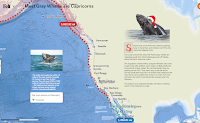
Felt is a multimedia mapping tool that I started using late last year. It has quickly become one of my preferred tools for creating multimedia maps. In fact, at this point I think I like more than Google’s My Maps. The aesthetics of Felt are great and it has a great selection of easy-to-use features. Those features include the ability to upload and overlay just images, easily draw paths and routes, and add text directly on your maps. All three of those things were used in the creation of a map titled Most Gray Whales are Capricorns.
Most Gray Whales are Capricorns is a map created by a Felt user who goes by RJ. The map depicts the annual migration of gray whales from the coast of Alaska to the coast of Baja California. The creator of the map added some fun elements to it by making some comparisons to the travel of gray whales in December to the travel of Santa’s reindeer in December. The creator of the map also included some links to additional information for readers.
Applications for Education
A map like Most Gray Whales are Capricorns is a nice example of what students can make with Felt. Felt has more ideas for educators right here and has an active Slack group for educators.


