
‘Polar Vortex’ Got You Baffled? Try This Extreme-Weather Guide
Many of the latest buzzwords in weather forecasting — “polar vortex,” “bomb cyclone” — describe natural phenomena that are not new, nor even necessarily more common than before, even as climate change, generally, has led to more weather extremes. But the terminology is in wider circulation, sometimes accurately, sometimes less so.
Polar Vortex
According to the National Weather Service, a polar vortex “is a large area of low pressure and cold air surrounding both of the Earth’s poles. It ALWAYS exists near the poles, but weakens in summer and strengthens in winter. The term ‘vortex’ refers to the counterclockwise flow of air that helps keep the colder air near the poles.” The polar vortex expands fairly regularly during winter in the northern hemisphere, ferrying Arctic air into the United States.
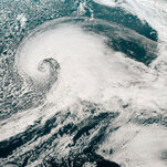
Bomb Cyclone
A bomb cyclone is a rapid pressure drop in a low-pressure air mass — “by at least 24 millibars in 24 hours,” said John Gyakum, a meteorologist at McGill University who helped coin the term in the 1980s. As the pressure difference, or gradient, grows between the low-pressure air mass and the neighboring higher-pressure air mass, the winds pick up sharply. This process of rapid intensification is known as bombogenesis.
Atmospheric River
Atmospheric rivers “are narrow regions in the atmosphere that transport much of the moisture from the tropics to northern latitudes,” according to the National Oceanic and Atmospheric Administration, or NOAA. “Atmospheric rivers are part of the Earth’s ocean water cycle, and are tied closely to both water supply and flood risks.”