
How Sensor-Dangling Helicopters Can Help Beat the Water Crisis
Sand and gravel are coarse particles, through which water travels rapidly. But when those ancient rivers created huge flood plains in the Central Valley, finer particles like clay would settle out of the water, creating less permeable layers of sediment through which water travels a million times slower. (Think about how quickly water disappears when you pour it on gravel or sand compared to pouring it on clay, where it pools.) In paleo valleys, those coarser sediments are topped with perhaps just a few feet of soil, so they readily channel water into the aquifer system—this is where you’d want to refill. But in other places in the Central Valley, aquifers might be covered with less-permeable layers of sedimentary clay—these are less promising areas.
One way of recharging an aquifer is to build basins, also known as spreading grounds, pumping stormwater in and allowing it to pool and gradually seep into the dirt. “If you build basins like that in the Central Valley, sitting over major clays, you'll get water in the ground, but it won't be nearly as successful as if you located a facility like that over one of these paleo valleys,” says Fogg. Much of that water will just pond on the surface and evaporate away—or, worse yet, cause flooding, which is what you’re actually trying to mitigate.
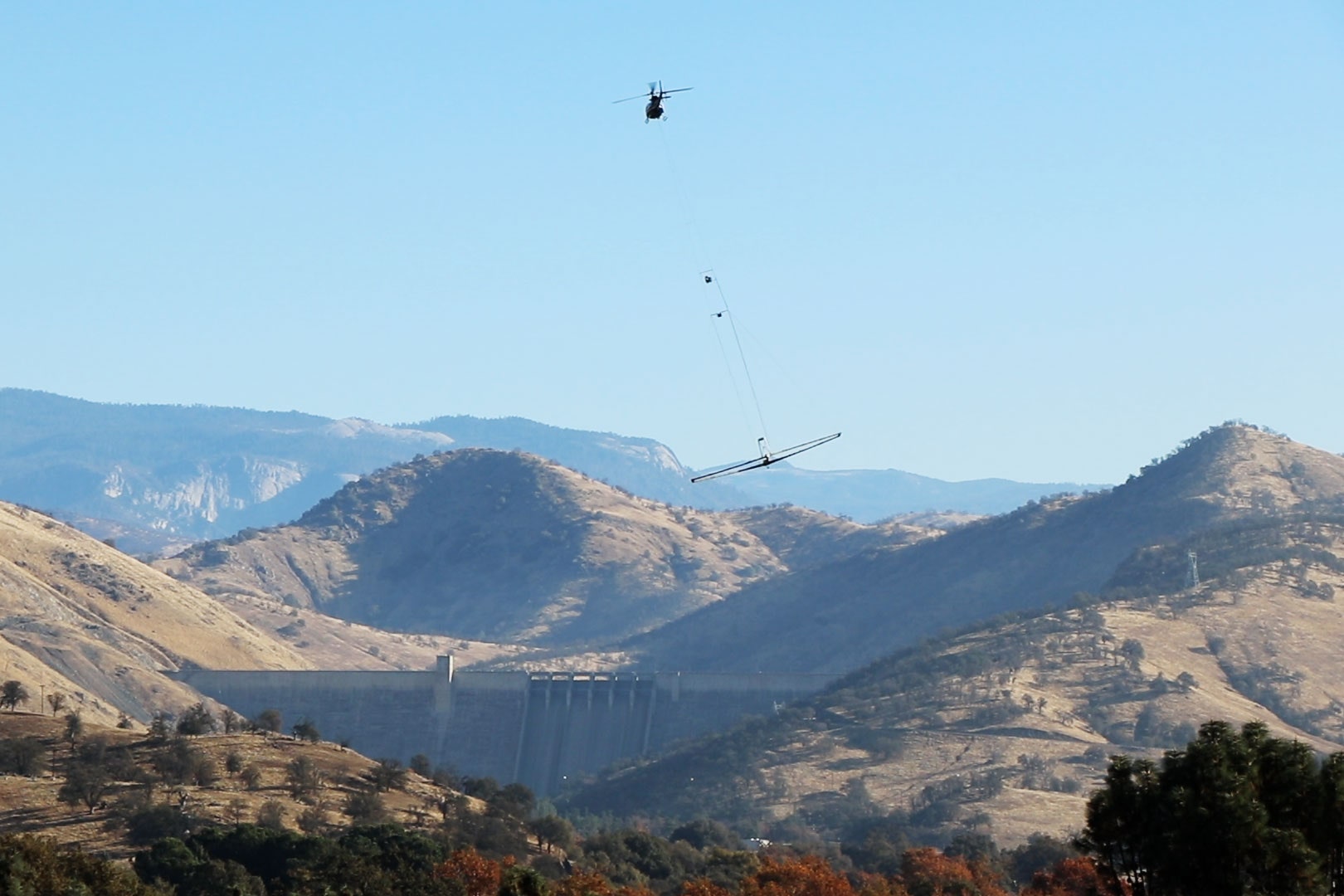
For Fogg and other scientists, the mission is to find the gravel and sand. And for that, they’ve got electromagnetism. The photo at the top of this story shows a helicopter dangling a loop that generates an electromagnetic field. This fires a current into the ground below, and the returning signal is picked up again by the loop. (Other researchers have used the same technique to map the subterranean plumbing of Yellowstone National Park.)
Because coarse sediments like sand and gravel conduct electricity in different ways than finer sediments like clay, that data will betray the composition of the earth, down past 1,000 feet deep. The scientists can accurately (and literally) ground-truth these measurements by doing flyovers of areas where they already know precisely what’s in sedimentary layers, for instance thanks to samples taken from drilled wells. To get an even more detailed picture, they’ll drag a smaller electromagnetic instrument behind an ATV.
Compared to the old way of getting sediment data—drilling a bunch of holes—it’s like doing a body scan ahead of surgery. “Along came medical imaging, and it revolutionized our approach to human health—you don't hear the words ‘exploratory surgery’ anymore,” says Stanford University geophysicist Rosemary Knight, who is helping pioneer these techniques. “In geophysics, you do the imaging and then you strategically place wells where you need more detailed information. It's not time-effective or cost-effective to walk along the edge of the Sierras to the mouths of the major rivers and have geologists out there looking at samples.”